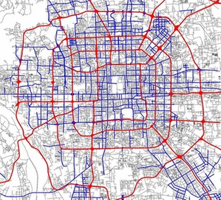
北京的交通一直受人詬病,即使是擴建數條地鐵和增開多條公交都無法緩解擁堵的道路,若不幸正巧趕上了高峰期,那就更悲劇了。有一個問題一直困擾著我們:北京為什么這么堵?
微軟亞洲研究院的一個團隊認為出租車的行駛路線或許能幫助我們找出城市交通網下潛在的頑疾,因此他們就仔細研究了2009年到2010年間33000輛北京出租車的GPS數據,并于近期在北京舉辦的第13屆普適計算大會( ubicomp )上論述了他們的研究。
Beijing is a city famous for traffic jams. In 2006, rush hour reportedly lasted 11 hours a day, and the city has been called a "virtual car park" during daylight hours. As in most major cities, urban planners have been trying for years to relieve the pressure by adding new roads or public transit lines, or providing better enforcement for traffic laws.
Now a group working at Microsoft Research Asia has shown that tracking the location of taxicabs could be a better way to identify the underlying problems with a city's transportation network, helping officials determine how to best ease congestion.
The researchers used GPS data from more than 33,000 Beijing taxicabs. That data was collected in 2009 and 2010. The researchers were not just looking for bottlenecks—trouble spots that regular commuters may know only too well. "[Congested] road segments are only the appearance—they're not the problem," says Yu Zheng, who led the research. "We try to identify the true source of the problem in our work."
The researchers presented their work last week at the 13th International Conference on Ubiquitous Computing, which took place in Beijing.
To get at underlying causes of traffic problems, the researchers needed to get information about the trips people are taking—where journeys start, finish, and how a commuter travels in between. The researchers divided Beijing into regions and analyzed the taxi data to find places where two regions weren't properly connected.
Even if a taxi never encounters a slowdown, clues from the trip can indicate an underlying problem with urban planning. For example, the taxi driver might take a circuitous route from point A to point B, instead of a direct one. The added distance could indicate that the driver knows about a problem with what appears to be the fastest route.
The researchers' algorithms indicate when the network of roads and subway lines between two regions cannot support the number of people traveling between those regions. By pointing out underlying problems, the system shows urban planners where to focus their attention, Zheng says.
In some cases, Zheng says, the busy regions aren't really the ones that are flawed. For example, it may be that people from region 1 are going through region 2 on their way to region 3, in which case it may be better to connect region 1 and 3 directly, rather than trying to widen highways in region 2.
The researchers evaluated their system by examining how their calculations changed as Beijing's transportation network evolved during the two-year period they monitored. They found that when city planners added new connections between regions that algorithms had identified as flawed, conditions did indeed improve. Where flaws were identified but not fixed, traffic conditions did not improve.
Zheng says the system could easily be adapted for any city that has a large number of taxicabs—many of which struggle with traffic in their own right. Beijing ranks fourth in the world for number of cabs. The top 10 includes Mexico City, Bangkok, Tokyo, New York, Buenos Aires, and Moscow. Zheng says that, with enough data, his techniques would work as well there as they do for Beijing.
"I think this is an interesting direction, though I wonder to what extent the real problem in urban planning is not having the resources—money—to do anything about it," says Sam Madden, an associate professor at the MIT Computer Science and Artificial Intelligence Laboratory who studies wireless sensor networks, including GPS units.
Madden adds that the huge quantity of data the researchers amassed—enough to analyze every road in a city—makes the work impressive. Even a few years ago, he says, it would have been a challenge to get so much information about road conditions. For his own research, Madden put GPS sensors on taxis to gather data, but cost and difficulty limited him to tagging tens of taxis, not thousands.
相關閱讀
交通擁堵費 congestion fee
奧運交通壓力大 1/3倫敦人須在家上班
李立新:交通擁堵的根本原因決不能完全歸結于車多
重點路段 traffic hotspots
(來源:technologyreview 編輯:Rosy)
